Reference
Plitvice Lakes Map Explained: All Sixteen Lakes and Where They Are
A map of Plitvice Lakes is easier to read once you know its shape. The lakes form a single chain about 8 km long, running from south to north through a valley between the Mala Kapela range and Lička Plješivica. Water enters at the top, at Prošćansko jezero (636 m above sea level), and steps down through sixteen named lakes to Novakovića Brod (503 m), where it leaves over the Sastavci falls as the Korana river. The twelve Upper Lakes fill the southern part of the chain; the four Lower Lakes sit in a narrow limestone canyon at the northern end, next to the Great Waterfall.
In the middle lies Kozjak, the biggest lake and the hinge of the whole map. A road, the D429, runs along the eastern side of the park past the two entrances: Entrance 1 in the north, by the Lower Lakes canyon, and Entrance 2 in the south, near Kozjak. The park says they are about 3 km apart. Everything else on the park map, from the boat docks marked P to the train stations marked St, hangs off that simple frame.
The map at a glance
- Direction: south to north, over about 8 km. Upstream is south, downstream is north.
- Height: from 636 m at Prošćansko jezero down to 503 m at Novakovića Brod, according to the Croatian Encyclopaedia.
- Two halves: twelve Upper Lakes on dolomite, four Lower Lakes in a limestone canyon, divided at Kozjak.
- Two entrances: Entrance 1 (north) and Entrance 2 (south), on road D429, about 3 km apart.
- Water transport: electric boats on Kozjak between docks P1, P2 and P3.
- Land transport: panoramic vehicles between stations St1, St2 and St3.
- Scale: the lakes cover just under 1% of a park of just under 300 km²; the rest is mostly forest.
Which way is up: the lakes run south to north
The first thing to work out on a park map is which way the water flows. The lakes are not arranged around a centre; they are a staircase. The Croatian Encyclopaedia describes them as running in a south–north direction for 8 km, and every lake is lower than the one before it.
That matters on the ground. If you walk from Entrance 2 towards the Upper Lakes, you are walking upstream and gently uphill. If you walk from Kozjak down through the canyon to the Great Waterfall, you are following the water downhill towards Entrance 1. The total drop through the chain is more than a hundred metres, taken in dozens of small steps over tufa barriers.
The setting explains the split into two halves. The park places the whole area within the Dinaric karst, and the lakes straddle two kinds of rock: impermeable dolomite in the south, which holds water in wide, open basins, and permeable limestone in the north, which the water has cut into a gorge.
The twelve Upper Lakes, top to bottom
The park lists the Upper Lakes as Prošćansko jezero, Ciginovac, Okrugljak, Batinovac, Veliko jezero, Malo jezero, Vir, Galovac, Milino jezero, Gradinsko jezero, Burgeti and Kozjak. On a map they look like a string of irregular pools threaded together by boardwalks.
- Prošćansko jezero is the highest and, after Kozjak, the largest, at about 0.68 km² in the encyclopaedia’s figures. Its outflow barrier grows three times faster than Kozjak’s.
- Ciginovac and Okrugljak follow immediately below, then Batinovac.
- Veliko jezero and Malo jezero, the “big lake” and the “small lake”, are a pair, with Vir just below.
- Galovac is one of the larger Upper Lakes and gives its name to the cascade Galovački buk.
- Milino jezero, Gradinsko jezero and Burgeti lead down to Kozjak. Gradinsko takes its name from the hillfort on the peninsula beside it.
- Kozjak closes the Upper Lakes and opens the Lower ones.
The park describes the Upper Lakes as larger than the Lower Lakes, with more indented and gentler shores, and wooded all round. Expect a map of this section to show many small falls and a dense network of paths.
Sizes vary enormously. After Kozjak and Prošćansko jezero, the encyclopaedia’s figures put Galovac next, at 0.12 km², with Gradinsko jezero at 0.083 km². At the other end of the scale, Milino jezero covers just 0.0012 km², little more than a pool between two barriers. On a small-scale map the smallest lakes can disappear into the lines of the boardwalks.
Kozjak, the hinge of the map
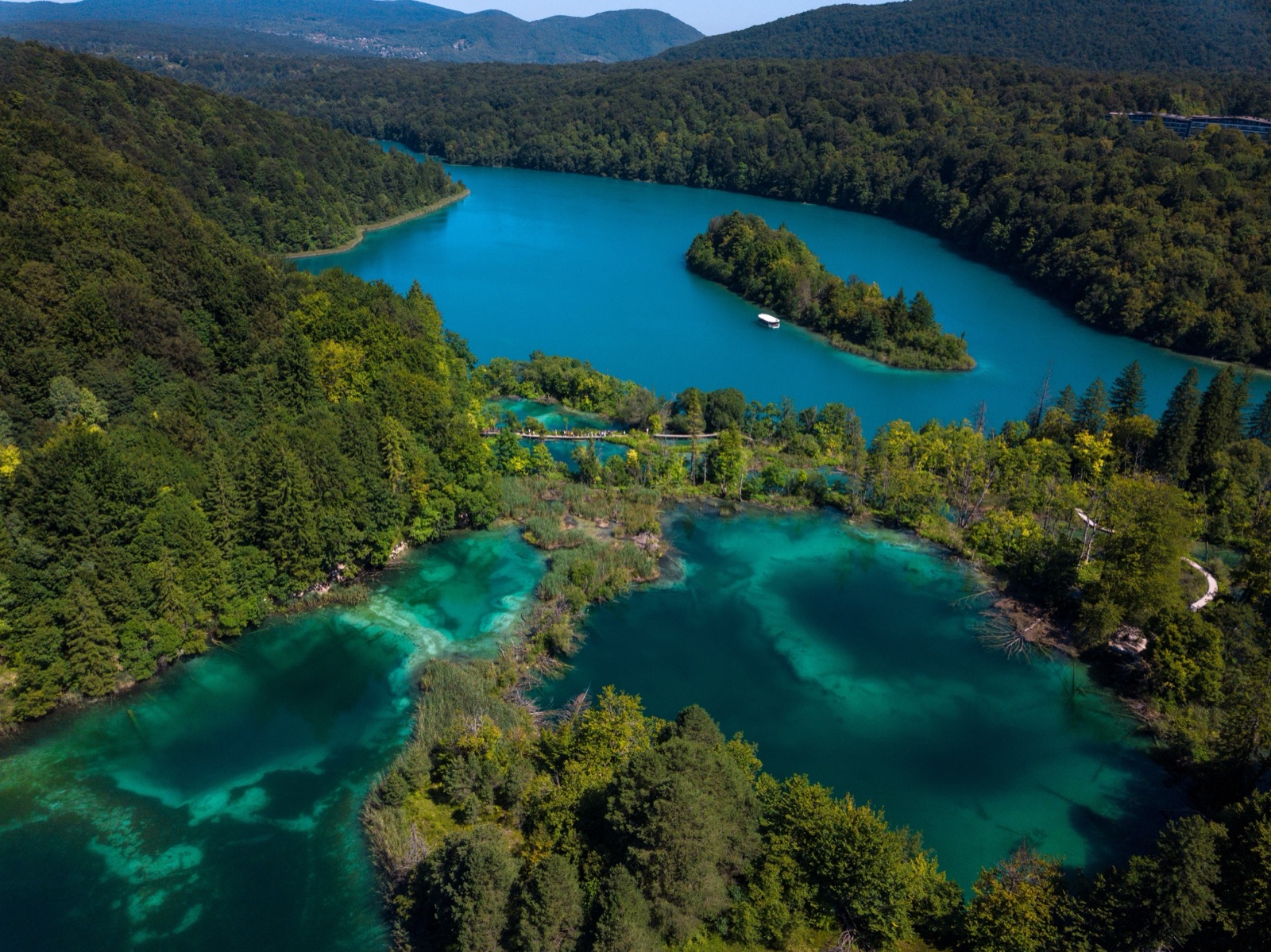
Kozjak is the lake you will recognise on any map: long, wide and in the middle. By the park’s figures it is the largest lake, at 82 hectares, and the deepest, at 47 m (the Croatian Encyclopaedia gives 46 m). It is the only lake with tourist boats and the only one with an island, Štefanija’s Island.
Kozjak also marks two boundaries. It is the border between the Upper and Lower Lakes, and between the Triassic dolomites to the south and the Cretaceous limestones to the north. Below the surface it hides a third feature: a drowned tufa barrier, about 400 m wide and about 36 m high, lying 6 m under the water. Until about 400 years ago it divided Kozjak into two lakes. On sunny days you can see it from the electric boat as a pale line in the dark blue water.
For map readers, Kozjak is where you change mode. The electric boats cross it, the docks on its shores link the two halves of the park, and the hotel area and Entrance 2 sit above its eastern shore.
The four Lower Lakes and the canyon
Below Kozjak the character changes completely. The Lower Lakes, Milanovac, Gavanovac, Kaluđerovac and Novakovića Brod, formed in permeable limestone and lie in a deep canyon with steep cliffs. On a map they appear as a narrow ribbon, with paths along the bottom of the canyon and along its eastern rim.
The canyon ends at the north of the park, close to Entrance 1. Here the Great Waterfall, the highest waterfall in Croatia, comes down the canyon wall, and the last lake, Novakovića Brod, spills over the Sastavci falls. The Croatian Encyclopaedia gives Novakovića Brod as the shallowest of the lakes, at 3 m deep, and the lowest, at 503 m. Our article on the Plitvice waterfalls covers the falls themselves in detail.
Where the water comes in and goes out
A map also shows the rivers at each end, and they explain why the lakes exist at all.
- In: the lakes are fed by the Crna and Bijela rivers, the Black River and the White River, and by the Rječica stream.
- The side stream: the Plitvica stream runs separately and drops into the canyon as the Great Waterfall. It does not belong to any of the sixteen lakes.
- Out: at the foot of the last barrier, the water of the lakes joins the Plitvica stream and forms the source of the Korana. The Korana then runs 134 km to Karlovac.
Between the two ends, the water is held up by tufa barriers that mosses and algae keep building. The park estimates that the lake system took shape 12,000 to 15,000 years ago and that the lakes now hold 22.95 million cubic metres of water.
Entrances, docks and stations: decoding the park map
The park’s own map uses a small set of codes. Once you know them, any route description makes sense.
Entrances. The park gives Entrance 1 (north) as 44°54’17.9”N 15°36’40.3”E and Entrance 2 (south) as 44°52’58.5”N 15°37’25.2”E. Both lie on road D429, which runs through the eastern part of the park. There is also an auxiliary entrance, Flora, near Entrance 2, with its own ticket desk. Copy the coordinates into your phone if you are driving; some websites give different positions for Entrance 1.
Boat docks (P). The electric boats run on Kozjak only. On the park’s spring 2026 timetable there is a short route between P1 and P2 and a long route between P2 and P3. P3 is the dock at Kozjačka Draga. Wooden rowing boats can be hired at dock P1.
Stations (St). The panoramic vehicles, often called the train, run between stations St1, St2 and St3. St3 is the Labudovac stop, up near the Upper Lakes.
Programmes. Routes are lettered rather than numbered. Four start at Entrance 1 and four at Entrance 2; the ones from Entrance 1 are marked in green on the information panels and those from Entrance 2 in orange.
Our tickets and routes guide explains which programme uses which boat and station, and how long each takes. For reaching the entrances, see getting to Plitvice Lakes.
Viewpoints you can find on the map
Some of the best views of the lake system are from above, and the map shows where to look.
- Tomićevo pogledalo, opened in 2024 at an altitude of 684.82 m, looks over five Upper Lakes: Prošćansko, Ciginovac, Okrugljak, Veliko and Malo jezero. The park’s long K programmes pass it.
- The east rim of the canyon. From the Great Waterfall a steep zigzag path climbs to the east side of the Lower Lakes canyon, which has numerous viewpoints over the lakes and cliffs.
- Tupi Medveđak (868 m), on the Medveđak ridge, looks over six lakes: Prošćansko, Ciginovac, Okrugljak, Galovac, Gradinsko and Kozjak.
- Turčić (801 m), the lowest of the three Medveđak peaks, looks over Kozjak, the Great Waterfall, Hotel Jezero and the villages of Poljana and Plitvica.
The Medveđak peaks are reached on the park’s hiking trails, not the boardwalks. Trail no. 1 starts at the Hladovina car park at Entrance 2, by the footbridge over the main road.
Beyond the boardwalks: forests and hiking trails
A full park map is mostly green. Three-quarters of the park is forest, and the lakes take up just under 1% of its area. In 1997 the boundaries were extended, and the park now covers just under 300 km², spread over two counties: Lika-Senj (90.7%) and Karlovac (9.3%).
The park ticket covers 22 km of trails through the lake system and 36 km of hiking trails. Two forest routes start at Labudovac (St3):
- The Plitvica trail, 9 km long, follows the Plitvica stream down to the Great Waterfall and ends at dock P3 at Kozjačka Draga.
- The Čorkova uvala trail, 21 km long, runs out to Čorkova uvala and returns over Mt Preka Kosa to join the Plitvica trail.
Čorkova uvala itself lies in the north-west of the park at 860 to 1028 m and covers 84 ha of beech and fir. On the park map it is well away from the lakes; the park advises that the start point at Čorkova uvala village suits organised groups with a ranger.
For any hiking trail the park’s advice is simple: always carry a trail map.
Place names around the edge of the map
The park map and the road signs use a handful of local names that are worth recognising, because hotels, bus stops and trail descriptions refer to them.
- Plitvica Selo is the village beside the Great Waterfall, at the end of the Lower Lakes and close to Entrance 1.
- Velika Poljana is the plateau by Kozjak where the first accommodation, the first hotel and the early villas were built; the old road reached it via Jezerce.
- Poljana and Plitvica are the villages you can pick out from the Turčić viewpoint, along with Hotel Jezero.
- Labudovac, at the upper end of the system, is panoramic station St3; Pansion Labudovac, an old inn between Prošćansko jezero and Okrugljak, carried the same name.
- Mukinje is the settlement where the park’s scientific station opened in 1975.
- Kozjačka Draga is the spot on Kozjak with boat dock P3, where the Plitvica trail ends.
If you are staying near the park, these names will appear in your directions; our article on Plitvice Lakes accommodation explains the options around the entrances.
Krčingrad: the castle on the map
One small symbol on the peninsula between Kozjak and Gradinsko jezero marks Krčingrad, the Kozjak hillfort. Gradinsko jezero is named after it, from gradina, a hillfort. Excavation has uncovered a triangular tower with sides of 16 metres, thought to date from the thirteenth century. The park notes that the site has been explored more thoroughly than any other archaeological locality in the area. Like the area’s other archaeological sites, it has not been presented for tourism, but it is a reminder that the lakes were a frontier long before they were a park.
How many lakes would a new map show?
Every map says sixteen, and the park still counts sixteen named lakes. But when its staff used aerial imagery from 2018 and a LiDAR elevation model to mark every separate body of water, counting any lake with a surface of at least 10 m², they found 90 lakes.
The difference is not a correction. The sixteen are the named lakes; the ninety include the many small, unnamed pools held up by their own tufa barriers. The park’s interest is in watching how that number changes, as barriers grow, merge lakes or split them.
The old maps
The lakes have been mapped for centuries, and the old maps show a different system. The park holds a map from 1774 to 1775 and another from between 1869 and 1887, and they show far fewer than sixteen lakes. Some of that is the cartography of the time; some may be real change.
Writers did not agree either. In 1860 Adolfo Weber Tkalčević described fifteen lakes and up to thirty larger and smaller waterfalls. Fifty years later Dragutin Franić described sixteen lakes, while noting that the names and the number of lakes were not yet settled. Even now the lists differ slightly: the Croatian Encyclopaedia, for example, lists Vir under the name Veliki Burget, while the park names Vir and Burgeti as separate lakes.
Getting a map
The park sells a printed tourism map at its information offices, at Entrance 1, Entrance 2, the Flora auxiliary entrance and train station 3, and in its souvenir shops. The park’s information panels show the lettered programmes in colour. If you are visiting with a guide, the route is chosen for you; a guided walk at the park is on our tours page.
Whatever map you use, keep to the marked trails. The park requires it, and the boardwalks are routed so that you can see the lakes without walking on the fragile tufa.
Frequently asked questions
Is there a map of Plitvice Lakes at the entrance?
Yes. The park’s information panels show the routes, with those from Entrance 1 marked in green and those from Entrance 2 in orange. The park also sells a printed tourism map at its information offices and souvenir shops.
Which way do the Plitvice Lakes flow?
From south to north. The water enters at Prošćansko jezero, the highest lake at 636 m, and flows down through the Upper Lakes, Kozjak and the Lower Lakes to Novakovića Brod at 503 m, leaving as the Korana river.
How far apart are Entrance 1 and Entrance 2?
The park says the main entrances are about 3 km apart, both on road D429 on the eastern side of the park. Entrance 1 is by the Lower Lakes and the Great Waterfall; Entrance 2 is near Kozjak and the Upper Lakes.
What do P1, P2 and P3 mean on the Plitvice map?
They are the electric boat docks on Kozjak. The short boat route runs between P1 and P2, and the long route between P2 and P3, which is at Kozjačka Draga. The St codes are the stations of the panoramic vehicles.
How many lakes are there at Plitvice?
Sixteen named lakes: twelve Upper Lakes and four Lower Lakes. A survey by the park using aerial images from 2018 counted 90 lakes in total once the small unnamed pools were included.